A decorative red asterisk that looks like it was made with a thick marker.

2026 Festival Maps

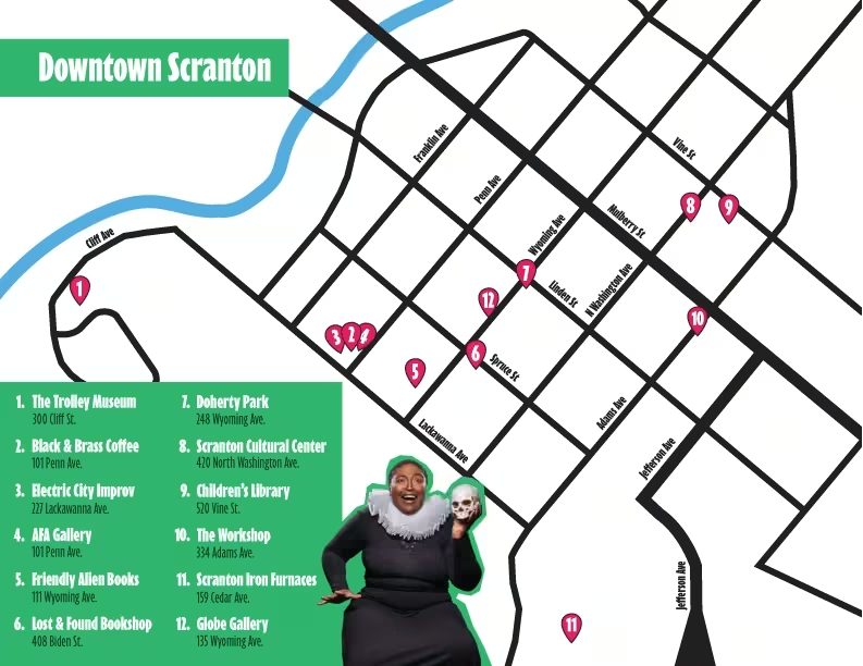
This is a high-contrast, graphic map of Downtown Scranton, created for the Scranton Fringe Festival. The color palette consists primarily of black lines for streets set against a white background, with bright green headers and legend panels, and magenta pink location markers.1 Image Structure & Layout Title Header: At the top left corner, there is a prominent bright green rectangular banner with the words "Downtown Scranton" written in bold white, condensed sans-serif text.1 Map Display: The central and right portion of the image features a stylized street grid map of downtown Scranton, marked with numbered magenta pin icons (1 through 12) showing specific venue locations. A bright blue wavy line at the upper left represents a river running parallel to Cliff Ave.1 Legend Panel: The bottom left corner contains a large bright green rectangular block featuring a numbered list of 12 numbered festival locations.1 Character Image: Positioned in the lower-middle portion of the image—partially overlapping the legend and map—is a cutout photo of a smiling woman. She is dressed in a black top with a large, white ruffle Elizabethan collar and is holding a white human skull in her left hand, mimicking a classic Shakespearean theatrical pose.1 Map Details & Street Grid The map shows several intersecting streets rendered as thick black lines:1 Parallel Streets Running Southwest to Northeast: Lackawanna Ave1 Spruce St1 Linden St1 Mulberry St1 Vine St1 Intersecting Streets Running Northwest to Southeast: Cliff Ave1 Franklin Ave1 Penn Ave1 Wyoming Ave1 N Washington Ave1 Adams Ave1 Jefferson Ave1 Legend & Numbered Locations The legend lists 12 numbered locations along with their street addresses:1 The Trolley Museum – 300 Cliff St. (Located on the loop at Cliff Ave on the far left of the map)1 Black & Brass Coffee – 101 Penn Ave. (Located near the intersection of Penn Ave and Lackawanna Ave)1 Electric City Improv – 227 Lackawanna Ave. (Located along Lackawanna Ave near Penn Ave)1 AFA Gallery – 101 Penn Ave. (Located adjacent to location 2/3 near Penn Ave and Lackawanna Ave)1 Friendly Alien Books – 111 Wyoming Ave. (Located on Wyoming Ave between Lackawanna Ave and Spruce St)1 Lost & Found Bookshop – 408 Biden St. (Located near the intersection of Wyoming Ave and Spruce St)1 Doherty Park – 248 Wyoming Ave. (Located on Wyoming Ave between Linden St and Mulberry St)1 Scranton Cultural Center – 420 North Washington Ave. (Located on N Washington Ave between Mulberry St and Vine St)1 Children's Library – 520 Vine St. (Located near the intersection of N Washington Ave and Vine St)1 The Workshop – 334 Adams Ave. (Located on Adams Ave near Mulberry St)1 Scranton Iron Furnaces – 159 Cedar Ave. (Located at the bottom center/right portion of the map)1 Globe Gallery – 135 Wyoming Ave. (Located on Wyoming Ave between Spruce St and Linden St)1
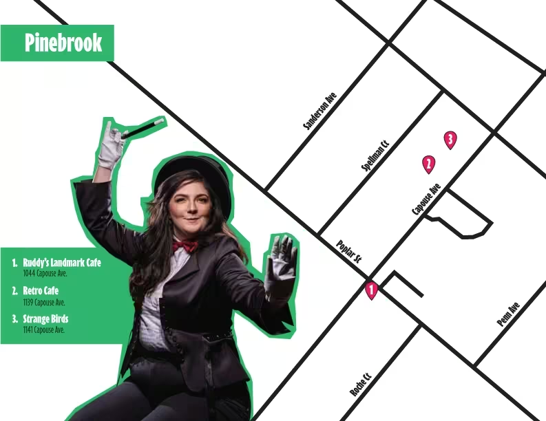
A map section for the "Pinebrook" area from the 2026 Scranton Fringe Festival is depicted.1 Foreground Character: On the left side of the map, there is an image of a person dressed as a magician wearing a black top hat, a black blazer, a white collared shirt, and a red bow tie. They are wearing white gloves, holding a magic wand pointed upward with their right hand, and holding their left hand open facing forward. The character is outlined with a thick green border.1 Text Box (Bottom Left): A green box overlaid near the magician lists three numbered locations:1 Ruddy's Landmark Cafe – 1044 Capouse Ave.1 Retro Cafe – 1139 Capouse Ave.1 Strange Birds – 1141 Capouse Ave.1 Street Map Details: The right side shows a high-contrast street grid with black lines representing roads on a white background:1 Main Avenues & Streets: Streets shown running parallel or perpendicular include Sanderson Ave, Spellman Ct, Capouse Ave, Penn Ave, Poplar St, and Roche Ct.1 Numbered Markers: Pink teardrop-shaped location pins with white numbers correspond to the list:1 Pin 1 (Ruddy's Landmark Cafe) is located near the intersection of Capouse Ave and Poplar St.1 Pin 2 (Retro Cafe) is located further up Capouse Ave between Poplar St and an upper cross street.1 Pin 3 (Strange Birds) is located slightly beyond Pin 2 along Capouse Ave.1 Header Box: A green box with white text in the top-left corner reads "Pinebrook".1
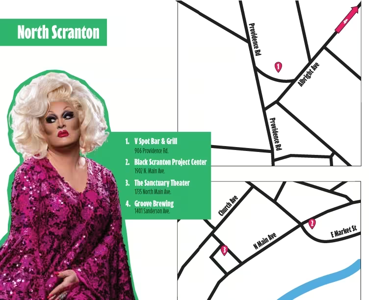
This image is a promotional map graphic for the North Scranton section of the 2026 Scranton Fringe Festival. The graphic features a prominent performer on the left side, a green information block listing four venues with their addresses, and two street map sections on the right showing the venue locations.1 Key Elements 1. Performer Image (Left Side) Description: A full-length portrait of a drag performer positioned on the left.1 Appearance: She has voluminous, styled blonde hair and dramatic makeup (dark eyeliner, bold eye shadow, defined eyebrows, and bright red lipstick).1 Outfit: She is wearing a long-sleeved, full-length dress completely covered in shimmering magenta and purple sequins with flared sleeves.1 Background Outline: The performer is silhouetted against a solid green backdrop that extends into the text area.1 2. Title & Venue List (Center-Left) Title Header: At the top left, a solid green rectangular banner contains the white text "North Scranton".1 Venue Information Box: Next to the performer, a green box displays a numbered list of venues and their addresses in white text:1 V Spot Bar & Grill – 906 Providence Rd.1 Black Scranton Project Center – 1902 N. Main Ave.1 The Sanctuary Theater – 1735 North Main Ave.1 Groove Brewing – 1401 Sanderson Ave.1 3. Map Diagrams (Right Side) The right half of the image features two stacked map sections with white backgrounds, black line representations of streets, and labeled street names. Pink numbered pin icons mark venue locations.1 Top Map Section: Shows the area surrounding Providence Rd and Albright Ave.1 Marker 1: Located just off Providence Rd, near the intersection with Albright Ave, indicating the location for V Spot Bar & Grill.1 In the top-right corner of this map, a pink arrow points northeast along a major road line.1 Bottom Map Section: Shows the area surrounding N Main Ave, Church Ave, and E Market St.1 A light blue curved line running along the bottom represents a river/body of water.1 Marker 2: Positioned near the intersection of N Main Ave and E Market St, indicating the Black Scranton Project Center.1 Marker 3: Positioned on N Main Ave near Church Ave, indicating The Sanctuary Theater
×


Please Wait
Talking to the Box Office...

×
Mobile Popup Menu